
We recently connected with Scott Thomas and have shared our conversation below.
Scott , thanks for joining us, excited to have you contributing your stories and insights. Coming up with the idea is so exciting, but then comes the hard part – executing. Too often the media ignores the execution part and goes from idea to success, skipping over the nitty, gritty details of executing in the early days. We think that’s a disservice both to the entrepreneurs who built something amazing as well as the public who isn’t getting a realistic picture of what it takes to succeed. So, we’d really appreciate if you could open up about your execution story – how did you go from idea to execution?
I’ve always been fascinated by perspective — how changing the way you look at something can completely transform what you see. That curiosity is really what led me into aerial imaging. Before Sky360 Aerial Media officially existed, I was simply out capturing the world from above, experimenting with drones, angles, light, and motion — trying to tell a story that the ground just couldn’t.
The “aha” moment came when I realized just how much untapped potential there was in this technology — not just for cinematic storytelling, but for data, analysis, and real-world problem-solving. I began noticing how much value high-quality aerial data could provide to industries like commercial real estate, construction, and infrastructure management. But to truly serve these industries, I needed to evolve beyond being a drone pilot — I had to build a company that understood both the artistry and the analytics behind what we were capturing.
Those early months were pure hustle. I spent countless late nights researching FAA Part 107 certification, learning photogrammetry workflows, and experimenting with software that could turn aerial photos into accurate 3D models. I remember creating my first 3D model of a building — it wasn’t perfect, but seeing a structure come to life in three dimensions from nothing but drone imagery was incredible. That moment made it real for me.
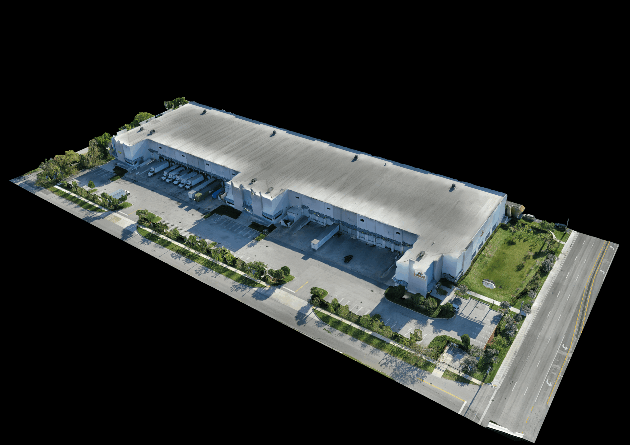
As the company grew, so did the vision. I wanted Sky360 to be more than just an aerial imaging company — I wanted it to be a complete visual intelligence partner. That meant expanding beyond the skies to also capture what’s happening on the ground and inside the structures themselves. Today, we pair our advanced aerial imaging with ground-based spatial data capture, including 360° walkthroughs and high-precision 3D scans of interiors and facilities. This combination allows us to create fully integrated digital twins — giving our clients a detailed, data-rich view of their properties from top to bottom, inside and out.
Of course, getting here wasn’t easy. The learning curve was steep, and I was wearing every hat imaginable: pilot, editor, marketer, and business owner. But every project pushed the boundaries a little further. Over time, clients began returning not just for the visuals, but for the clarity and insights our data provided — whether for facade inspections, energy efficiency assessments, or property marketing. That’s when I knew Sky360 wasn’t just a creative outlet anymore; it was a platform for helping people truly understand and manage their physical environments in smarter, more informed ways.
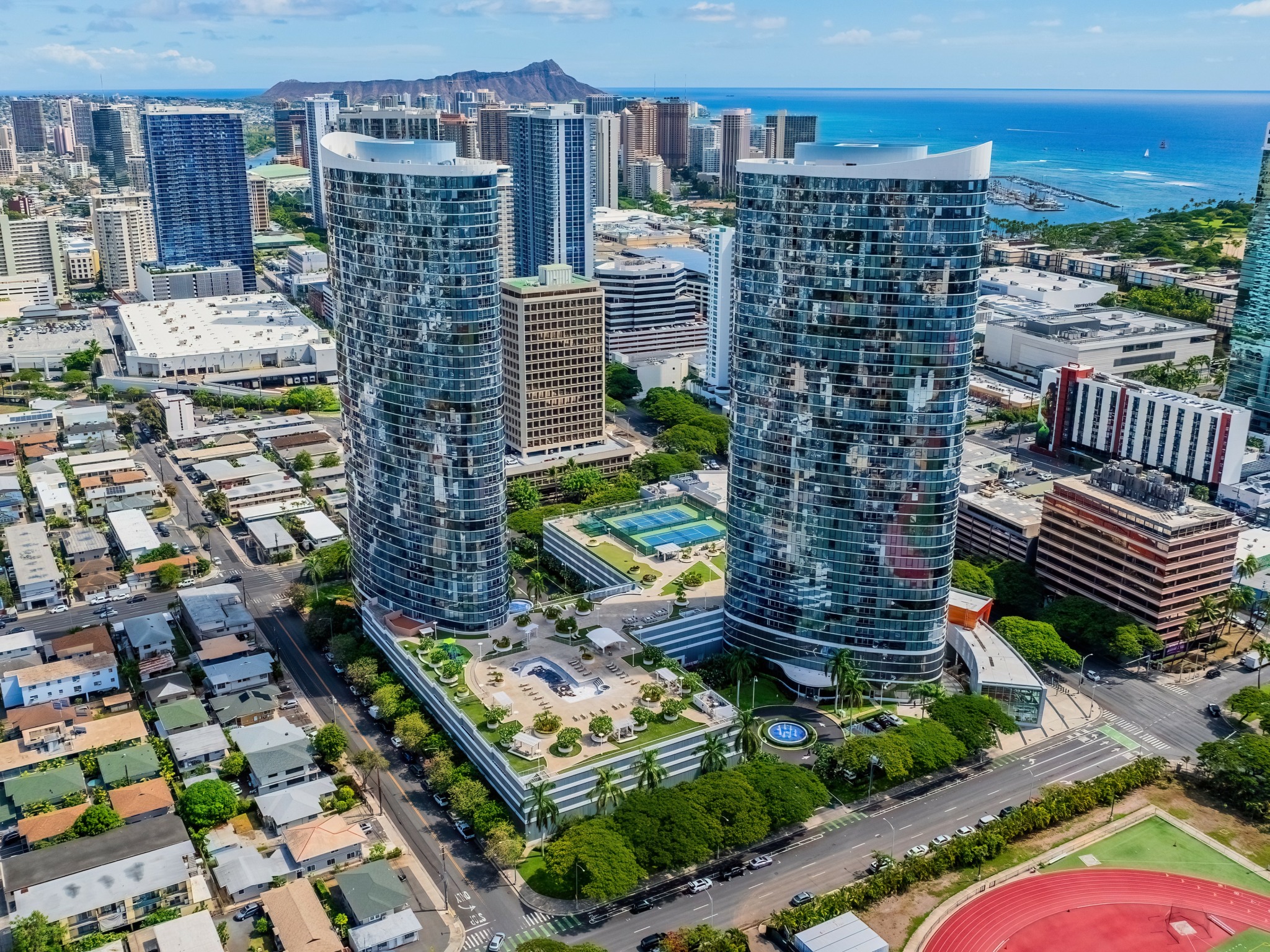
Today, that same curiosity that started it all still drives me. Whether we’re flying thermal imaging missions over high-rise towers, mapping large-scale developments, or capturing immersive ground-based 3D models, the goal is the same: to blend technology, creativity, and precision data into something that helps our clients see their world more clearly — and make better decisions because of it.
Scott , love having you share your insights with us. Before we ask you more questions, maybe you can take a moment to introduce yourself to our readers who might have missed our earlier conversations?
My name is Scott, and I’m the founder of Sky360 Aerial Media, a visual data and imaging company based in Atlanta, Georgia. My journey into this industry began with a deep fascination for two things: technology and perspective. I’ve always been drawn to the intersection of creativity and innovation — where visual storytelling meets data-driven insight. When I first began flying drones, it was out of pure curiosity. I was amazed at how these small flying machines could reveal the world from entirely new angles. But what started as a passion for aerial photography quickly evolved into something much bigger.
I realized that the same technology used to capture beautiful imagery could also be used to solve complex real-world problems — especially in industries like commercial real estate, construction, and facility management. That realization became the foundation for Sky360 Aerial Media. Today, we specialize in aerial data capture, 3D modeling, and thermal imaging — helping our clients visualize, analyze, and manage their properties and assets with greater precision than ever before.
What truly sets us apart is that we bridge the gap between artistry and analytics. Our work isn’t just about creating stunning visuals — it’s about delivering meaningful, measurable insights. From high-resolution facade inspections on skyscrapers to detailed 3D mapping for engineers and architects, we provide the kind of visual intelligence that helps our clients make smarter decisions, faster.
We’ve also expanded beyond aerial imagery to incorporate ground-based 3D imaging and spatial data capture. This means we can create complete digital twins of buildings and facilities — from the top of the roof down to the mechanical rooms inside. The result is a comprehensive visual record of a property that can be used for everything from maintenance and inspections to marketing and design planning.
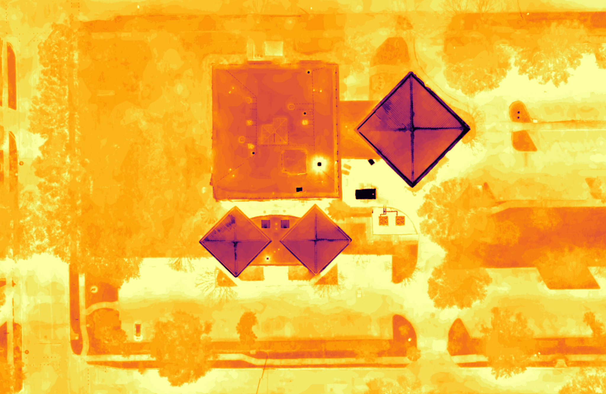
One of the biggest challenges our clients face is accessibility — both in terms of safety and information. Inspecting a high-rise curtain wall or a rooftop HVAC system can be risky, time-consuming, and expensive. With our advanced drone systems, including the DJI Mavic 3 Enterprise and Mavic 3 Thermal, we’re able to capture detailed imagery and thermal data safely from the air. This technology allows building owners, engineers, and asset managers to identify issues early — corrosion, heat loss, water intrusion, or facade damage — without ever having to put someone in harm’s way.
At the same time, we bring a strong creative edge to our work. For our real estate and marketing clients, we produce cinematic aerial videos, immersive tours, and visual content that elevates how properties are presented. Whether we’re showcasing a new development or highlighting a remote parcel of land, our mission is always the same: to tell a property’s story in a way that’s both visually powerful and strategically valuable.
What I’m most proud of is how far Sky360 has come — not just in the sophistication of the technology we use, but in the trust we’ve built with our clients. We’re not a drone company that just flies and delivers footage. We’re a visual solutions partner. Every project is a collaboration aimed at uncovering insights, improving safety, and helping clients make better decisions about their assets.
At its core, Sky360 is about clarity, connection, and confidence. We help people see what was once invisible — whether that’s a heat anomaly behind a facade panel, a construction detail on a complex structure, or simply the beauty of a property from the air. And we do it with precision, creativity, and integrity.
If there’s one thing I want potential clients and collaborators to know, it’s that our work goes beyond imagery — it’s about perspective. We combine cutting-edge technology with a deep understanding of how visuals can drive action, inspire confidence, and ultimately create smarter, safer, and more sustainable environments.
How about pivoting – can you share the story of a time you’ve had to pivot?
One of the most pivotal moments in my career came early in the journey with Sky360. When I first started experimenting with drones, my initial focus was purely on capturing stunning aerial photography and cinematic imagery. It was exciting work, but as I began working with clients, I quickly realized that the real value wasn’t just in beautiful visuals — it was in the data those visuals could provide.
I remember a client, a large commercial property manager, asking if we could help them identify maintenance issues on a high-rise facade using the imagery we captured. At first, I thought, “We’re photographers, not engineers.” But as I explored the possibilities, I realized that combining drones with 3D modeling, thermal imaging, and advanced sensors could deliver actionable insights that went far beyond marketing footage. That was the moment I knew I needed to pivot.
Pivoting wasn’t easy. It meant investing in new technology, learning the nuances of thermal imaging and photogrammetry, understanding how building engineers and facility managers think, and building a completely new workflow around data collection and analysis. I had to shift the mindset from “creative aerial content” to “data-driven aerial solutions.” It took months of research, experimentation, and building trust with clients who were willing to try this new approach.
But the pivot paid off. Not only did it open new revenue streams, it fundamentally changed the way Sky360 is positioned in the market. Today, our clients rely on us not just for visual storytelling, but for critical insights that help them manage assets more efficiently, safely, and intelligently. That willingness to pivot — to see beyond the obvious and embrace a broader vision — has been one of the defining moments of both my career and the growth of Sky360.
Can you share a story from your journey that illustrates your resilience?
One story that really highlights resilience came during a project for a client who needed detailed aerial and thermal imaging of a mid-rise commercial building. When we arrived on-site, we faced a twofold challenge: the weather was shifting with high winds, and the building was located in controlled airspace, which required coordination with Air Traffic Control to fly safely and legally.
Most teams might have postponed or canceled, but we were determined to deliver on time. Using our specialized FAA Part 107 training and experience, we communicated directly with Air Traffic Control, obtained temporary airspace clearance, and reprogrammed our flight paths to safely navigate the conditions. Even with these obstacles, we completed the full 3D mapping and thermal inspection, capturing all necessary data without compromising safety.
That day was a reminder that resilience isn’t just about endurance—it’s about problem-solving, adaptability, and leveraging expertise to overcome complex challenges. By staying calm, thinking creatively, and relying on both our technology and regulatory knowledge, we turned a potentially delayed project into a success story for our client.
Contact Info:
- Website: https://www.sky360aerial.com
- Instagram: https://www.instagram.com/sky360aerial
- Facebook: https://www.facebook.com/Sky360AerialMedia
- Linkedin: https://www.linkedin.com/company/sky360aerialmedia
- Twitter: https://x.com/Sky360Aerial
- Youtube: https://www.youtube.com/@sky360aerialmedia

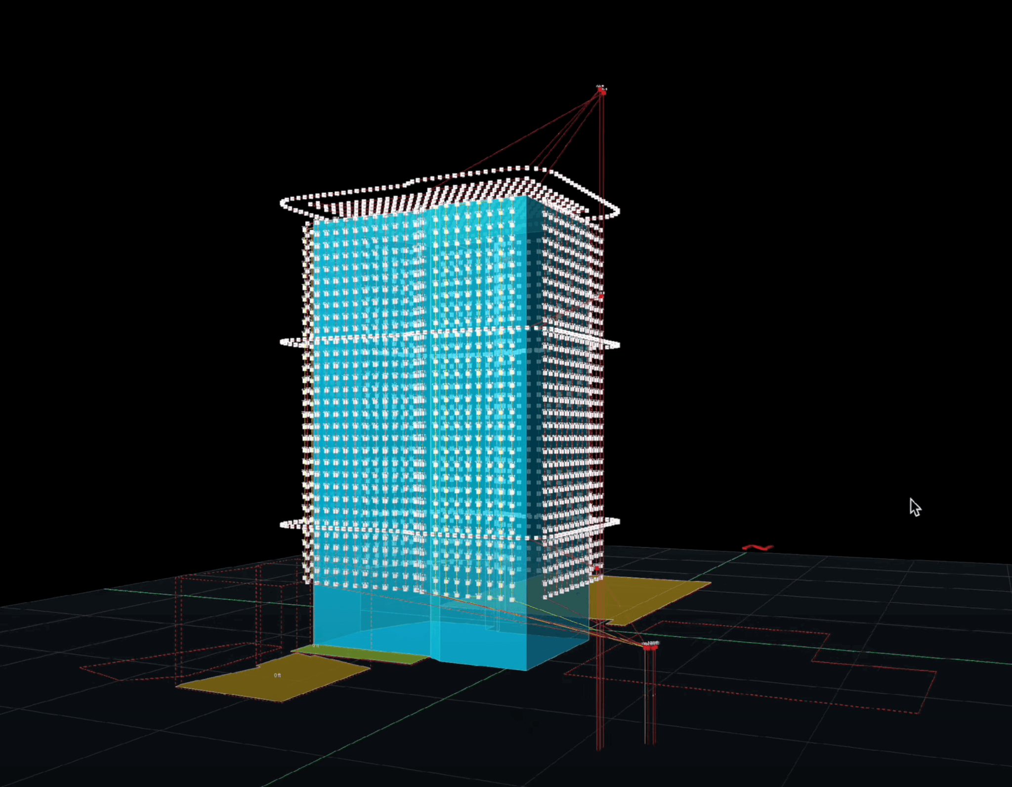
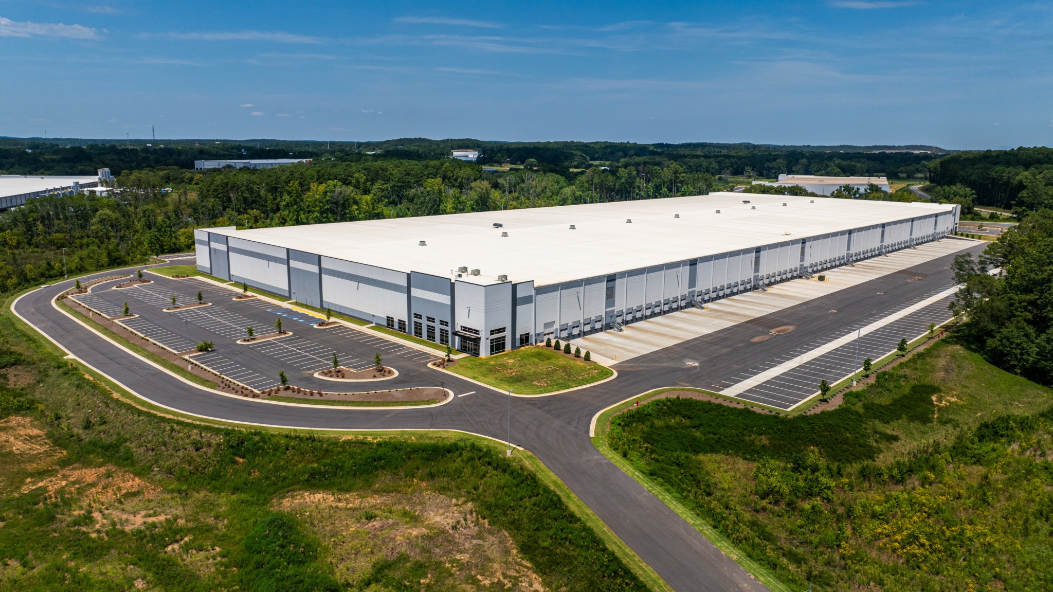

Image Credits
All images photographed by Scott Thomas, Sky360 Aerial Media.